Integrated Greenhouse Gas Monitoring System (ITMS)
Project background
The Integrated Greenhouse Gas Monitoring System (ITMS) — or, in German, Integriertes Treibhausgas-Monitoringsystem (ITMS) — is a national project contributing to the World Meteorological Organization’s Integrated Global Greenhouse Gas Information System (IG3IS).
ITMS can be integrated into the Deutscher Wetterdienst (DWD) operational systems as one of its service components. The system focuses on monitoring the key long-lived greenhouse gases — carbon dioxide (CO₂), methane (CH₄), and nitrous oxide (N₂O) — through independent measurements.
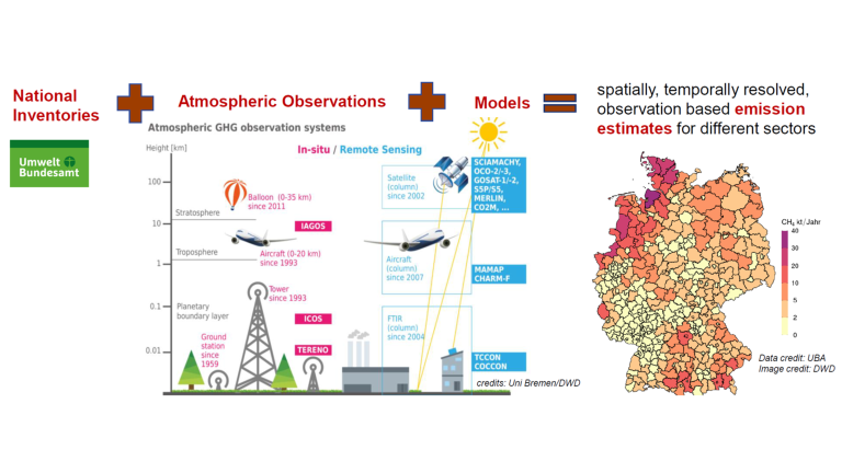
Its vision is to integrate atmospheric observations from ground, air, and space with high-resolution bottom-up flow models and atmospheric inverse models. The system aims to document greenhouse gas sources and sinks, support user needs, and provide an independent monitoring, reporting, and verification (MRV) framework for emissions from diffuse sources such as agriculture and industry.
Embedded within European research initiatives such as Copernicus and the Integrated Carbon Observation System (ICOS), ITMS delivers high-resolution, long-term data on greenhouse gas sources and sinks for German stakeholders, European Union programmes, and the scientific community.

The ITMS combines greenhouse gas concentration measurements from observation systems with atmospheric transport models and existing emission information.
Credit: Andrea Kaiser-Weiss
Objectives
The ITMS project will deliver in its first project phase (see ITMS Timeline) a prototype system for a new German CO2, CH4, and N2O emissions monitoring and verification support capacity that can be implemented within the DWD operational systems as one of its service elements.
From 2022 to 2026, the ITMS project works towards the following main objectives to develop a demonstrator system:
- Develop a system to characterize, quantify, and monitor greenhouse gas sources and sinks in Germany.
- Support and review national greenhouse gas inventory reports.
- Characterize sources and sinks by:
- Identifying regional hotspots
- Quantifying diffuse sources
- Differentiating between anthropogenic and natural contributions
- Provide advice to industry and policymakers on mitigation measures and assist other countries in developing greenhouse gas monitoring systems.
Timeline
The planning involves three phases (see Figure):
- Phase 1 is a development phase providing a demonstrator ITMS.
- Phase 2 aims at establishing a first-generation ITMS capable of providing regular information on GHG emissions based on numerous observational data streams.
- Phase 3 is concerned with the transition to a fully operational system at DWD.
Outcomes
The overall outcome of the ITMS is planned to include:
- Online provision and visualization of natural and anthropogenic GHG sources and sinks for Germany, sector-specific as well as adequately spatially resolved and temporally sampled.
- Support for Monitoring, Reporting, and Verification (MRV), especially the national inventory reports, and aiding scientific evidence for certificate trading.
- Detecting over- and underestimation of sources and sinks, thereby reducing uncertainties with respect to sectorial attribution as well as spatio-temporal variability.
- Regional hotspot characterization.
- Differentiation of natural and anthropogenic contributions, and the quantification of diffuse sources and sinks of GHGs, such as agriculture, forestry, and other land use (AFOLU), as well as traffic.
- Integration of German observing and modelling capabilities to set up a national service, i.e., enabling the continuous use of Copernicus services, EU research projects, ICOS, IAGOS, as well as satellite data for advising society and policy.
- Evaluation and improvement of observational strategies and supporting other countries in implementing GHG observation systems.
- Target-oriented consultancy of industry and policy about the success of mitigation measures.
International collaboration
International collaboration is essential to ensure high-quality far-field observations, expand observing systems, compare models and inversions, and promote scientific exchange and coordinated communication. ITMS cooperates with international partners in research in the following areas:
- Further development of the understanding of the relevant source and sink processes.
- Improved spatial and temporal resolution of bottom-up descriptions of anthropogenic and biogenic sources and sinks.
- Development of top-down model systems for the operational environment, including the interaction with global models.
- Optimization of the use of in-situ (ground-based and airborne) and satellite-based remote sensing data (Sentinel-5 Precursor (S5P), OCO-3, GOSAT-2, the French-German cooperation MERLIN, and, in perspective, data of the Sentinel satellites S2, S5, and CO2M).
