

Methodologies
Existing approaches
Reporting of anthropogenic emissions happens at all scales, from nations to cities and enterprises. The typical reporting approach is an inventory – combination of the activities data with emission factors (also called a “top-down approach”). The complexity of this approach depends on capacity of the reporting body and spans from Tier 1 (basics) to Tier 3 (the most comprehensive and adapted to specific circumstances). National reporting of anthropogenic GHG emissions is regulated by the UNFCCC while the guidelines are provided by the IPCC Task Force on National GHG Inventories (IPCC TFI).
IG3IS Approach
The IG3IS approach brings together atmospheric observations and modelling to quantify emissions and removals at spatial scales and resolutions tailored to the needs and capabilities of different users (a "top-down" approach).
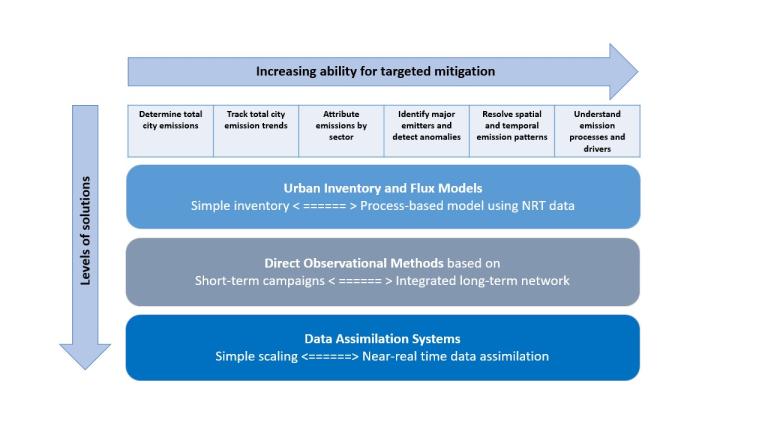
The level of method complexity is driven by the established user needs as depicted in Fig.1 for the urban scale applications.
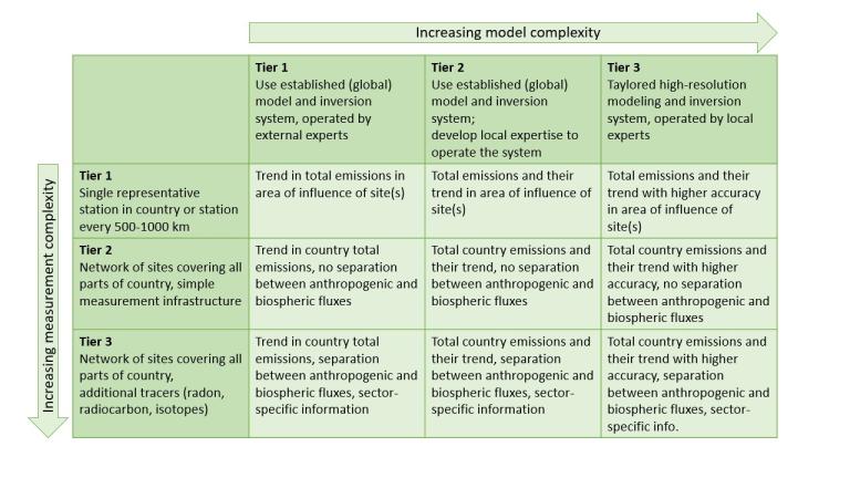
For the national scale, the approach is tiered as shown in Figure 2, with varying levels of measurement and modelling sophistication. Some countries may require only a rough estimate of emissions and trends, which can be provided at a lower tier. Others may need more accurate data, including sector-specific emissions, requiring a higher tier.
How does IG3IS work?
The methodology uses ground-based, airborne, and space-based observations of the specific GHG with high spatial and temporal resolution. Measurement data is processed using atmospheric inverse modelling systems or other analysis tools to generate top-down estimates of GHG fluxes between the surface and atmosphere. The inverse modelling system incorporates atmospheric transport from state-of-the-art meteorological models with an inverse algorithm that optimizes the GHG fluxes needed to reproduce the observed distribution of each GHG in the presence of the modelled wind field. Initial information on the fluxes based on socioeconomic data and information on natural fluxes is used in inverse modelling systems as prior information. Additional observations of co-emitted species or isotopic composition may be required for source attribution.
The IG3IS community focuses on existing-use cases where IG3IS information can meet the expressed (or previously unrecognized) needs of decision-makers, their documentation through “good practice” guidelines for different application areas, and the initiation of new projects and demonstrations that propagate and advance these good practices.
To ensure the best possible quality of the information products, additional observations created through IG3IS pilot projects are used for model benchmarking and performance evaluation.
Benefits of observation-based emission estimates
- Provide a critical new data source for objective monitoring of GHG emissions, removals and trends complementing bottom-up GHG inventories.
- Offer a comprehensive source of information detailing the spatial, temporal and sectoral distribution of emissions and removals, with improved timeliness to support monitoring and management efforts.
- Account for both anthropogenic and natural emissions and removals.
- Can be scaled and consistently applied from facility to national levels.
- Can be tailored to produce information products relevant to specific user communities.
- Offer clear, updated insights to help stakeholders understand dynamic emissions and refine their strategies to maximize the effectiveness of proposed climate solutions.